
Malick Diagne is the head of GeoRisk Afric, a company founded in March 2016. He attended training sessions on drone usage for precision agriculture organised by CTA and the French company, Parrot, as part of the “Eyes in the Sky” project. In this blog, using his 12 years’ experience in environmental and natural resource management, the Senegalese head of the company explains the fascinating and critical innovation opportunities that drones provide for the gathering of geospatial data.
Agriculture is at the heart of our business at GeoRisk Afric. We concentrate our services on the areas of cartography, risk management for natural disasters and environmental studies: drones for precision agriculture are a clear positive progression of the actions we are able to deliver for agricultural development in Senegal. Drones also offer new and innovative partnership opportunities with potential clients such as the Senegalese National Agricultural Insurance Company (CNAAS), the National Fund for Agricultural Loans (CNCAS), the Department of Agricultural Analysis, Forward Planning and Statistics (DAPSA) and the Directorate of Civil Defence for Environmental and Industrial Risk Management.
The training in precision agricultural drones provided by CTA’s “Eyes in the Sky” project, discovered by chance on a social network, provided the perfect opportunity for GeoRisk Afric to move into a fast-growing market. Opportunities like this do not come around very often.
Eyes in the Sky: putting theory into practice
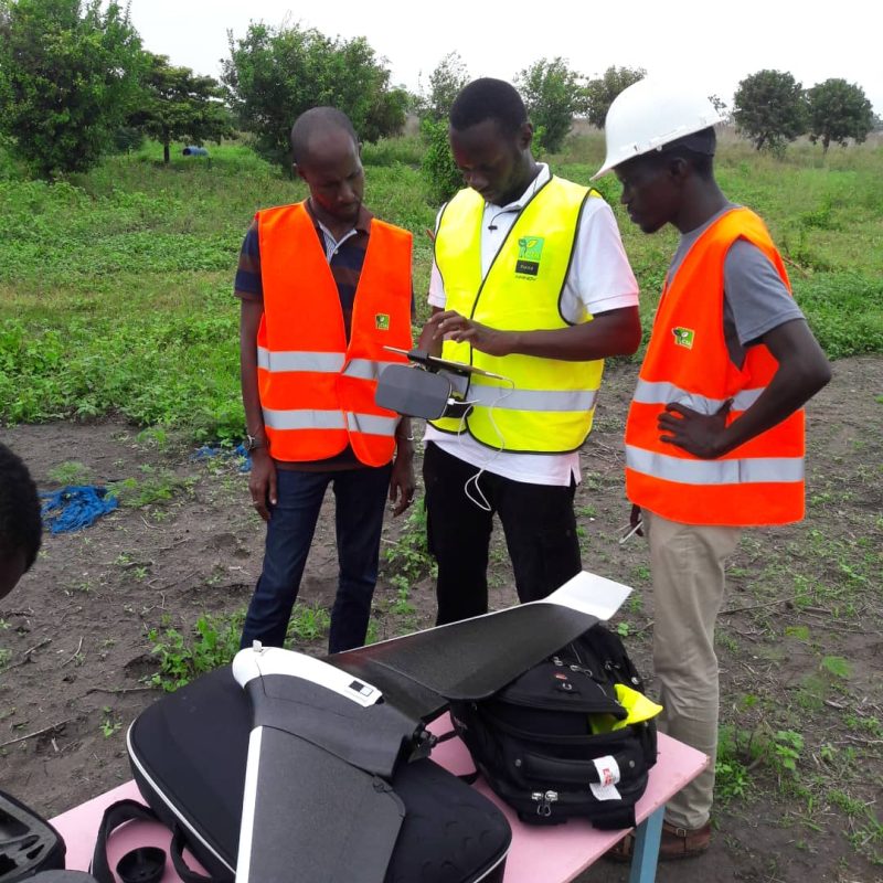
From the 11th to the 18th July 2018 in Lusaka, Zambia, I attended, along with participants from a dozen other African nations, several training modules focusing on the usage of drones. These sessions were run under the guidance of a group of experts: Giacomo Rambaldi, Senior Programme Coordinator for CTA, Hamza Rkha Chaham, Director General of SOWIT, Walter Volkman, an expert on positioning systems, Thomas Subi, founder and Co-Director of the company iDrone Services, and Captain Maxwel N Cjama, Operations Inspector for the Zambian National Civil Aviation Authority. Two other members of the GeoRisk Afric team also attended with me: Alassane Mbengue, Cartography Specialist, and Mami Thioro Diouf, Head of Communications and Marketing.
The modules covered:
- Applications for drones in agriculture and other fields related to geolocation data;
- Business Management (led by Ernst & Young);
- Digital Communications;
- Latest regulatory changes from the African Union relating to drone usage.
The training was made possible thanks to funding from Parrot, and was held at the Cape Coast University, Ghana, from 2-4 October 2018. The content: piloting exercises (manual and automatic), security precautions and guidelines for each flight mission and how to utilise the data collected.
GeoRisk Afric to offer drone services
There are numerous potential applications for using drones in agriculture in Senegal, a sector which employs nearly 60% of the population. We are planning to grow our involvement in this area to include crop inventories, disease and water stress detection and crop estimations. The use of drone services will bring significant added value, especially as Senegalese agriculture is heavily dependent on rainfall. This would allow state authorities in charge of agricultural management to benefit from accurate, reliable data allowing them to successfully manage campaigns for the distribution of agricultural inputs. In the same context, we want to help insurance companies with accurate estimations of damage caused to crops due to bad weather and lack of rainfall. This would allow all parties (farmers, insurance companies, grass-roots community organisations, local communities, etc.) to have access to important data which will help assist their decision making.
For example, we are working with the CNAAS to build an index-based insurance project which is based on historic data on yields and returns, and real-time data from drones to help define, based on the index that we will construct, the insurance parameters. These parameters will therefore be based on accurate crop data, thanks to the drones. Another example is the cartography of horticultural zones, which we offer free of charge to the Directorate of Horticulture in order to conduct, on behalf of the Sustainable and Inclusive Development Project for Agribusiness in Senegal (PDIDAS), a monitoring of horticultural crops via drone, with the support of agronomists, in order to provide recommendations on the usage of fertilisers (Nitrogen, Phosphorous, Potassium or NPK) for each square metre of farmed land.
With their training certificates in hand, GeoRisk Afric is now ready to conquer the Senegalese market. I can count on CTA’s network to help me meet potential clients, as well as on the network of participants we met in Zambia and Ghana. In November 2018, I went to Sindia and Sébikhotane, 70km from the capital, to test my drone. This adventure has only just begun. The possibilities and opportunities are endless. The usage of drones for agriculture could well be the significant boost to Senegalese agriculture that we have all been anticipating.
Orginally Published: https://www.cta.int/en/blog/all/article/drones-could-become-one-of-the-main-drivers-of-agricultural-growth-in-senegal-sid05c7e5d03-f44a-4cb1-b33e-89e73ca61bfd